- home
- News
- Technology
- Cyber
- HLS
- Innovation
- Unmanned
- Video
- Events
- Accelerators
- עברית
- Subscribe
- Contact Us
- home
- News
- Technology
- Cyber
- HLS
- Innovation
- Unmanned
- Video
- Events
- Accelerators
- עברית
- Subscribe
- Contact Us
Geospatial
Drone Integration into Airspace – New Solution
Commercial drone operations have huge potential in the smart city setting, supporting emergency response, reducing emissions and air pollution and increasing access to food,...
9th Unmanned Systems Conference AUS&R and AUVSI, this Time as Broadcast
September 7, 2020
The unmanned systems market has become one of the most trendy and interest-provoking fields in the Israeli and global arenas. Even the...
COVID-19 Constraints – Mixed Reality Tech Being Tested for Airports
Large industrial operators are keen to understand how to maintain the integrity of their electricity network to the highest standard while operating in an...
First Rules on Safe Use of Drones at Urban Environments
New European standards under preparation will contribute to the safe operation of drones for a wide variety of services, such as parcel delivery in...
Call for Startups: Do You Have Innovative Technological Project?
Apply to iHLS Security Accelerator’s 8th Batch
Specializing in security technology with an emphasis on dual-use technology, iHLS is inviting startups in this field to...
Managing Battle with Android Application
Dismounted soldiers will now have an enhanced battlefield management and situational awareness capabilities when using an Android smartphone geospatial infrastructure and military situation awareness...
Collaboration in Unmanned Aerial Systems Field
Unmanned aerial systems (UAS) activities are now accepted worldwide as a vital sector of aviation. The mission is therefore to achieve the safe, efficient,...
Australian Technology to Enable Underground Navigation
Drones usually rely on GPS for localization, navigation and flight control. A new technology uses LiDAR data and advanced algorithms on-board in real-time to...
Location Intelligence Giant to Boost First Response Capabilities
Location is the most important piece of information in an emergency. With over 80 percent of 911 calls coming from cell phones—many of them...
Call for Startups – Apply to iHLS Security Accelerator 8th Batch
Are you developing a ground-breaking technology in the fields of unmanned systems, coping with COVID-19 pandemic, counter drones, border security, safe city?
We invite you...
Quantum to Enhance Precision Navigation
Precision navigation in GPS-denied environments has been highlighted by the US Institute for Defense Analyses IDA as a key application for quantum technology, with...
Pinpointing the Drone Operator
Malicious drones can cause vast damage to aircraft, infrastructure, etc. One of the challenges is the detection of their operators. Currently, drone operators are...
Bio-Inspired Technology to Help Drones Navigate in the Dark
A new sensor technology with potential for application in drones has been inspired by mosquitoes. Some mosquitoes are night owls of the insect world,...
First Drone U-Space in Scandinavia Announced
Mapping, infrastructure inspections, precision agriculture, delivery of goods and e-commerce are just some of the services possible using drones. Countries worldwide are competing to...
US Smartphone Location Data Exposed
Smartphone tracking data is never completely secure. This is the conclusion that can be drawn from the recent investigation in the US. Members of...
Drone Use as Game Changer in Rescue Incidents – Now it’s Documented
A new online reference map to track rescue events around the world shows how drone technology has moved from an experimental concept to standard...
Cyber Experts: COVID-19 Patient Tracking in Israel Should Be Transferred from Israeli Security Agency to New, Dedicated and Independent Agency
Regarding information leaks from the database: It’s a question of “when” rather than “if”.
The cellular tracking technology - Obsolete
In a special panel regarding the...
Major Step Towards China’s Independence in Global Navigation Field
The Chinese Beidou navigation network will be complete this month when its final satellite goes into orbit, a move that will complete a global...
AUS&R 2020 – Attend the Leading Unmanned Systems and Robotics Event
Thanks to their accelerated technological development and their endless applications, unmanned systems on the ground, air, and sea currently attract the highest interest both...
Has COVID-19 Accelerated Drone Delivery Flights in Israel?
For the first time: BVLOS Multi-Drone Test Flight Authorized by Israel’s Civil Aviation Authority
Within the framework of preparations for drone flights for various missions...
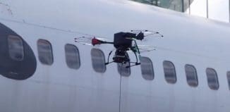
Drone Solution turns Aircraft Hangar into Smart Facility
Aircraft maintenance requires skills and complex equipment. An unmanned aerial system will now be able to perform aircraft inspection during maintenance. The Civil Aviation...
Towards InnoTech Expo Launch Event – Interview with Conference Chairman
iHLS is proud to launch iHLS InnoTech Expo Tel-Aviv - Israel’s largest conference and exhibition for HLS and cyber technologies and innovation. The launch...
Latest
Copyright © 2012 i-HLS. All Rights Reserved.


